Map of surface temperatures of the oceans and seas
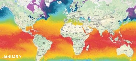
Depending on the country, latitudes and months of the year, bathing temperatures can fluctuate strongly or very little. The animation shows the thermal mass of the seas of the globe, with a warm red zone of 86°F (30°C) rising from the southern hemisphere in winter to the northern hemisphere in summer.
So you guess you have to go south in winter to find a sea temperature above 82°F (28°C) for bathing and of course stay in our hemisphere in summer but always more in the south anyway close to the equator!

Sea and ocean surface temperatures are data collected over the whole year by satellite radars and all around the Earth. The sea takes a long time to warm up or cool down. This inertia makes it possible to have constant average values in general and thus predetermine the best months for bathing. The first two meters of water on the surface of the sea, stockpile the equivalent of all the energy contained in the atmosphere. This surface pouch acts as an enormous heat reservoir. Moreover, in the lagoons and shallow surroundings of beaches, the temperature can be higher by 1 to 3 degrees.
How to use?
Select your month below, then flip over this dynamic map on the left. Geolocate the part of sea that interests you on the planisphere. With your mouse wheel, it is best to zoom in. Move the active area to compare with the temperature scale that frame your area. This gives you the average temperature of the bathing water according to the chosen month.
January
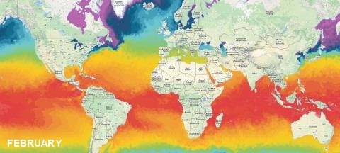
February
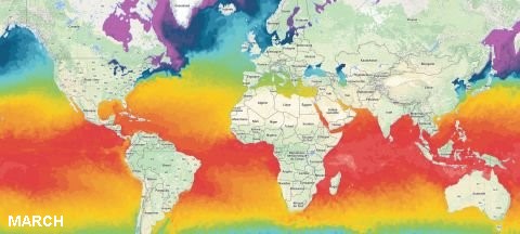
March
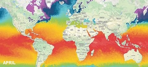
April
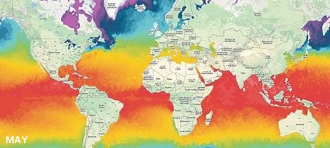
May
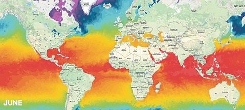
June
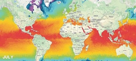
July
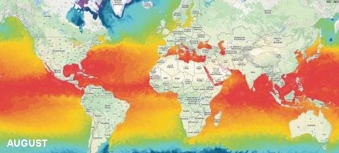
August

September
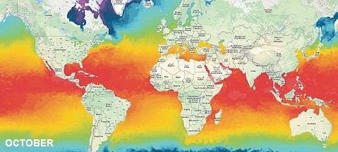
October

November
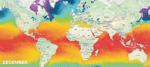
December
Correlation between ocean surface temperature and winds
Oceans and seas cover 70% of the earth's surface. As temperature radar animation shows, in general, the large hot thermal mass is mainly around the equator and between the tropics. Ocean dynamics is mainly driven by atmospheric circulation due to terrestrial rotation (Coriolis). The pressures (anticyclonic and low pressure) but especially the winds cause shifts of currents at the surface. These water currents describe cellular movements that are also related to the density of water, salinity and temperature.
The winds create the currents that carry warm water cells into the tropics. The warm trade winds do not cool the surface of the sea. On the other hand, to give a local example in France, in august, three days of Mistral (famous wind from the Alps) blowing on the french Riviera cool the Mediterranean Sea which has difficulty reaching the 79°F (26°C). The lowering or raising of bathing temperatures does not occur in a few hours but over several days thanks to or because of the inertia of the surface water mass.
- See the Seas and oceans temperatures scale
- See the ranking of seas and oceans of the world