Willemstad, CURACAO and its best beaches
Climate - Temperatures and rainfall - Caribbean Sea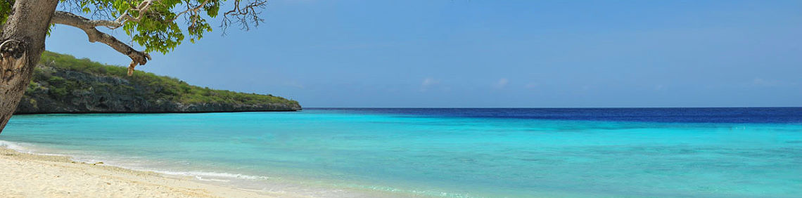
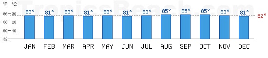
Willemstad: Temperatures during the day, at night, rain and bathing conditions
|
January Day temperature  83°F / 28°C |
Night temp. 83°F / 28°C |
Night temp.  76°F / 24°C |
Bathing temperature 76°F / 24°C |
Bathing temperature  83°F / 28°C |
Rain 83°F / 28°C |
Rain  053 mm |
Conditions 053 mm |
Conditions   
|
|
February Day temperature 85°F / 29°C |
Night temp. 74°F / 23°C |
Bathing temperature 81°F / 27°C |
Rain 025 mm |
Conditions
|
|
March Day temperature 85°F / 29°C |
Night temp. 74°F / 23°C |
Bathing temperature 83°F / 28°C |
Rain 020 mm |
Conditions
|
|
April Day temperature 86°F / 30°C |
Night temp. 76°F / 24°C |
Bathing temperature 81°F / 27°C |
Rain 028 mm |
Conditions
|
|
May Day temperature 86°F / 30°C |
Night temp. 77°F / 25°C |
Bathing temperature 83°F / 28°C |
Rain 020 mm |
Conditions
|
|
June Day temperature 88°F / 31°C |
Night temp. 79°F / 26°C |
Bathing temperature 81°F / 27°C |
Rain 025 mm |
Conditions
|
|
July Day temperature 88°F / 31°C |
Night temp. 77°F / 25°C |
Bathing temperature 83°F / 28°C |
Rain 038 mm |
Conditions
|
|
August Day temperature 88°F / 31°C |
Night temp. 79°F / 26°C |
Bathing temperature 85°F / 29°C |
Rain 030 mm |
Conditions
|
|
September Day temperature 90°F / 32°C |
Night temp. 79°F / 26°C |
Bathing temperature 85°F / 29°C |
Rain 028 mm |
Conditions
|
|
October Day temperature 88°F / 31°C |
Night temp. 79°F / 26°C |
Bathing temperature 85°F / 29°C |
Rain 107 mm |
Conditions 
|
|
November Day temperature 86°F / 30°C |
Night temp. 76°F / 24°C |
Bathing temperature 83°F / 28°C |
Rain 112 mm |
Conditions
|
|
December Day temperature 85°F / 29°C |
Night temp. 76°F / 24°C |
Bathing temperature 81°F / 27°C |
Rain 099 mm |
Conditions
|


Curacao : climate and when to go to Willemstad
Curacao is called the Netherlands Antilles with as capital Willemstad. The tropical climate is sunny with tropical showers in July and August. The months from February to June are the ideal time to travel to Curacao and it is best to avoid the months of October, November and December a little watered for lazing lying on a towel at the beach. In Willemstad the air temperatures are constant almost all year round, between 82°F and 88°F on average. The Netherlands Antilles consists of two zones, one to the north, Saint-Martin, Saint-Eustache and Saba and another to the south, the leeward islands of Bonaire, Curacao and Aruba. These tiny islands of the Caribbean offer tremendous scenery, beautiful sandy beaches for relaxation and sumptuous seabed for a dream vacation.
| January Pecfect |
February Pecfect |
March Pecfect |
April Pecfect |
May Pecfect |
June Pecfect |
July Pecfect |
August Pecfect |
September Pecfect |
October Acceptable |
November Acceptable |
December Acceptable |
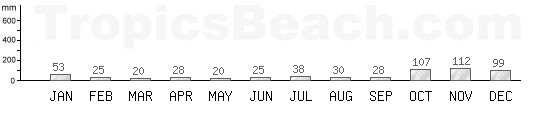
When to go? The hottest month for the beach, lazing around and swimming is September. Check the precipitations because showers are possible but the sun returns quickly, otherwise other periods are possible. The coolest month is January, if you can not stand the heat too much. The driest month of the year is March, if you do not like the rain at all.
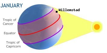
Click on
Willemstad to display its climate.
Graphs and temperature curves with average precipitation over the year


Precipitation, rainfall, cyclone: CURACAO
Temperatures of bathing water around Willemstad
Landmarks
Perfect conditions to enjoy the beach. Favorable conditions for enjoying the beach. Cloudy with sunny spells and thunderstorms.
 Very strong tropical or monsoon rains.
 Months at risk of cyclones with alerts level 1 to 5. Nice swimming at more than 26°C / 79°F. Everything is perfect for traveling.
No cyclone risk for this country


Caribbean Sea
Climate July 2026


Willemstad sunshine in summer and winter

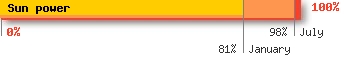
The sun at its zenith, that means well perpendicular to the surface of the Earth, sending 100% of radiation and heat. Willemstad receives in winter (january), 81% of sun power and 98% during summer time (july).
The average temperature and sunshine deviations between summer and winter are 17%. This small gap means that the temperature at sea does not really vary and that the sea remains warm enough in summer and winter. The air is also hot all year round without great thermal amplitude.

Average temperatures and rainfall for a stay in July
On the left, the averages observed every month of July on the Curacao beaches. The trends for next month are, the same daytime average temperatures, a bathing water in Caribbean Sea which takes a few degrees, less rainfall with warmer nights.
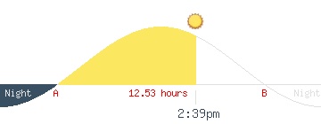
Sunset and sunrise times for CURACAO
Local time : July 2026, Tuesday 21, 12:24 AM
Sunrise time : 06:22 am, point A
Sunset time : 7:01 pm, point B
Duration of daylight : 12:39 / 24:00
Jet lag : GMT-4
The average monthly UV index of CURACAO
What is the period of mosquitoes virulence over the year?
Weather forecast for Willemstad
Here are the current 5-day forecasts for Sint Michiel Liber / Willemstad. Temperatures are spaced 3 hours apart for each day. The summary of the state of the sky gives the trend of the week. The sea temperature at is a monthly average. In lagoons or seashores where the bathing water is shallow, you can add some degrees.
Wednesday
July 22, 2026
8 am
80.9°F
28°C

Light rain
Humidity 82%
Sea 83°F/28°C
Wednesday
July 22, 2026
11 am
81.4°F
28°C

Overcast clouds
Humidity 79%
Sea 83°F/28°C
Wednesday
July 22, 2026
2 pm
83.2°F
29°C
Overcast clouds
Humidity 80%
Sea 83°F/28°C
Wednesday
July 22, 2026
5 pm
87.2°F
31°C
Light rain
Humidity 81%
Sea 83°F/28°C
Wednesday
July 22, 2026
8 pm
89.6°F
32°C
Overcast clouds
Humidity 83%
Sea 83°F/28°C
Wednesday
July 22, 2026
11 pm
79.6°F
27°C
Overcast clouds
Humidity 85%
Sea 83°F/28°C
Thrusday
July 23, 2026
8 am
79.3°F
27°C

Scattered clouds
Humidity 86%
Sea 83°F/28°C
Thrusday
July 23, 2026
11 am
79.3°F
27°C
Light rain
Humidity 86%
Sea 83°F/28°C
Thrusday
July 23, 2026
2 pm
79.4°F
27°C
Light rain
Humidity 86%
Sea 83°F/28°C
Thrusday
July 23, 2026
5 pm
80°F
27°C
Light rain
Humidity 85%
Sea 83°F/28°C
Thrusday
July 23, 2026
8 pm
79.9°F
27°C
Light rain
Humidity 85%
Sea 83°F/28°C
Thrusday
July 23, 2026
11 pm
79.8°F
27°C
Overcast clouds
Humidity 86%
Sea 83°F/28°C
Friday
July 24, 2026
8 am
79.7°F
27°C
Overcast clouds
Humidity 84%
Sea 83°F/28°C
Friday
July 24, 2026
11 am
79.8°F
27°C
Overcast clouds
Humidity 84%
Sea 83°F/28°C
Friday
July 24, 2026
2 pm
79.8°F
27°C
Overcast clouds
Humidity 85%
Sea 83°F/28°C
Friday
July 24, 2026
5 pm
80°F
27°C
Overcast clouds
Humidity 84%
Sea 83°F/28°C
Friday
July 24, 2026
8 pm
79.9°F
27°C
Overcast clouds
Humidity 85%
Sea 83°F/28°C
Friday
July 24, 2026
11 pm
79.8°F
27°C
Broken clouds
Humidity 86%
Sea 83°F/28°C
Saturday
July 25, 2026
8 am
79.6°F
27°C
Overcast clouds
Humidity 85%
Sea 83°F/28°C
Saturday
July 25, 2026
11 am
79.5°F
27°C
Overcast clouds
Humidity 85%
Sea 83°F/28°C
Saturday
July 25, 2026
2 pm
79.7°F
27°C
Overcast clouds
Humidity 86%
Sea 83°F/28°C
Saturday
July 25, 2026
5 pm
79.7°F
27°C
Overcast clouds
Humidity 84%
Sea 83°F/28°C
Saturday
July 25, 2026
8 pm
79.7°F
27°C
Overcast clouds
Humidity 83%
Sea 83°F/28°C
Saturday
July 25, 2026
11 pm
79.7°F
27°C
Broken clouds
Humidity 82%
Sea 83°F/28°C
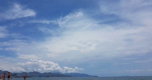
Weather uncertainties 2026 to go to Willemstad ?

When traveling in the tropics as a seaside, rain is not welcome. If you see this indicator, with possible storms, that does not mean that it will rain all day long. When we observe the local rainfall, it is either really zero or very weak. Meteorologists prefer to be pessimistic. So observe below, the skies photographed during a week announced stormy in Asia. It did not rain once. I invite you to integrate this parameter before going to Willemstad for a good trip to the sun!